Post #7a - Recreational areas & beaches - Comox Valley North
There are 26 posts in this blog, please visit them all.
<<<< See side bar for more
A Pictorial View of the Comox Valley
Recreational areas in the Comox Valley
North of the City of Courtenay
_________________________
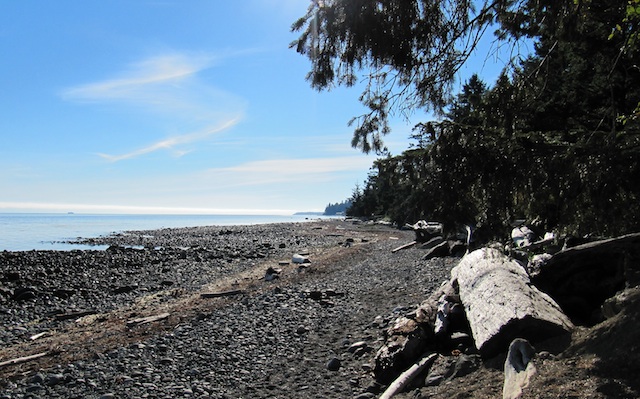
Kitty Coleman Beach & Park
Location
Kitty Coleman Beach & Park is located 6 kilometers northwest of Courtenay on central Vancouver Island. This park is accessed via Coleman Road off Hwy 19A, north of Courtenay. Turn on Left Road, then right on Whittaker Road until you reach the park. Nearby communities include Courtenay, Comox Valley, Merville and Campbell River.
Situated on the south side of the Strait of Georgia, Kitty Coleman Provincial Park is a popular destination for swimming, boating, fishing, hiking and oceanfront camping. The park protects the mature forest of Western hemlock, Western red cedar and Douglas fir in the upland portion, the estuary of Kitty Coleman Creek, and 900 meters of shoreline. Park facilities include a picnic shelter, picnic tables, pit toilets, two boat launches, several nature trails and camping for individuals and groups.
History - The original park was donated to the settlers of Merville around 1900 and operated by the community until the 1940s, when financial difficulties led to the province assuming management responsibility. Kitty Coleman was established as a Class “C” Provincial Park in 1944, and a community park board was set up to oversee its operation.
Special Features: The eastern portion of the park is home to a single majestic old-growth Douglas fir, estimated to be more than 500 years old. Wild onions can also be found growing throughout the area. Kitty Coleman Park is located 6 kilometers northwest of Courtenay on central Vancouver Island. This park is accessed via Coleman Road off Hwy 19A, north of Courtenay. Turn on Left Road, then right on Whittaker Road until you reach the park. Nearby communities include Courtenay, Comox Valley, Merville and Campbell River.
Some of the above information is from the following web site.
http://www.env.gov.bc.ca/bcparks/explore/parkpgs/kitty_coleman_bch/
Kitty Coleman Beach & Park
|
 |
Sign at Kitty Coleman Beach Entrance
|
 |
Kitty Coleman Beach
|
 |
Kitty Coleman Beach Douglas Fir
|
________________________________________________________
Bates Beach
 |
Road sign at the end of Aldergrove Road and the access to a section of Bates Beach
|
You will notice the birth and death date of Davey Janes on the road sign, this is the first time I have seen dates on regular road signs. David William Janes born 1912 and died 2002, was first a logger then a fisherman, he was married, his wife's name Sally Janes, his children, Greg Janes and Norma Janes.
(Thank you to Norma Janes for sending me the correct information on the family, RR)
Bates Beach
Bates beach is the name of a community along the Georgia Strait. There is a beautiful Oceanfront Resort in the area which has camping, boating, kayaking, fishing and more. There are a few public access points to the waterfront which is mostly rocky, with tidal pools and sand bars.
 |
Bates Beach area at the end of Davey Janes Road
|
 | |||
Bates Beach area at the end of Davey Janes Road
|
 |
| Sign at entrance to Seal Bay Park |
 |
| Alex checking out the trees on pathway at Seal Bay Park |
 |
| Beach area at Seal Bay Park |
 |
| Map showing trails at Seal Bay Park |
 |
| Plaque for Jim Egan at Seal Bay Park |
 |
| Plaque for Jim Egan is on this burl at Seal Bay Park __________________________ |
Miracle Beach
Located on the waterfront midway between Courtenay and Campbell River, this park provides easy access to both communities and a wealth of entertainment. On the beach, sandcastle building, sunning, swimming, exploring tide pools or just frolicking along the shore are all part of the Miracle Beach experience. And don’t miss the non-competitive annual sandcastle building day in June, where playful people of all ages create fantastic sculptures for all to enjoy....................
Miracle Beach Provincial Park is located 22 km north of Courtenay and 22 km south of Campbell River off Hwy 19a. From Hwy 19 take exit #144 (Hamm Road) to Hwy 19a (the Oceanside Route). Head north a short distance to Miracle Beach Drive, then drive 2 km straight into the park. Nearby communities include: Campbell River, Comox Valley, Merville
_______________________________________________________

|


contact information - my new e-mail is rhodapross@shaw.ca
ReplyDelete