There are 26 posts in this blog, please visit them all.
<<<< See side bar for more
A Pictorial view of the Comox Valley
Comox First Nations
_______________
First Nations
"Comox" is an anglicization of kw'umuxws, which is derived from the Kwakw'ala term, kw'umalha, meaning "plentiful; rich, wealthy". The Comox people are classified culturally as Northern Coast Salish. They spoke the Island Comox dialet of the Comox Coast Salish language; the last speakerof the dialect died in 1995. At the time of first contact with the Europeans in 1792, the Comox speaking groups occupied settlements extending along Vancouver Island from the vicinity of Salmon River in the northwest to the area around Cape Lazo in the southeast, including Quadra Island and other islands adjacent to Vancouver Island (Comox Land Use and Reserve History, 1999........
http://www.ihosgallery.com/history.html
____________________
History
Historically, the Island Comox territory extended from Salmon River to Cape Lazo/Point Holmes, and included Quadra Island. However, by the time of contact with Europeans in 1792, the Lekwiltok had already begun their aggressive southward expansion that would eventually displace the Island Comox from their homelands. Many of the remaining Island Comox settled around Comox Bay and Denman Island and lived among the Pentlatch whose territory extended from Cape Lazo to Fanny Bay. The Pentlatch at this time were already greatly affected by diseases and battles. Together the Island Comox and the Pentlatch (once old enemies) sought friendship and alliance for mutual protection and defence against the invading Lekwiltok. Since the mid to late 1800s, the Comox have been composed of descendants of Pentlatch, various Island Comox local groups, and Lekwiltok who together formed a village at the old winter village of the Pentlatch. Today, the Comox Indian Reserve No. 1 is situated near this former village site.
_________________________
The Comox Indian Reserves
Reserve #1, The main community (I-Hos Gallery is located here) is at Comox Indian Reserve #1, adjacent to the Town of Comox. The Comox Indian Reserve #1 was allocated in 1867. There are 160 people living on Comox First Nation Reserve, including 106 members and 54 non-member residents....
Reserve #2, The Pentledge Indian Reserve #2, which is partially developed and has good development potential, is located at the confluence of the Puntledge and Tsolum Rivers adjacent to the City of Courtenay. The Pentledge Indian Reserve #2 was also allocated in 1867.
Reserve #3, Goose Spit, the smallest reserve, is located on a narrow marine sand spit at the Comox Harbour entrance. The reserve formerly known as Graveyard Indian Reserve #3 was also allocated in 1867. Access to the reserve is greatly limited by an existing military base.
______________________________________
Reserve #1
 |
The beautiful house front design of I-Hos, incorporates a whale, "Queneesh" and the double headed sea serpent,"I-Hos". These creatures represent important crests of the Comox people. Standing inside of the entrance pole is a sxwayxwey (kway kwat) dancer. The dancer wears a mask with protruding eyes and tongue The dancer a carries scallop shell rattle and wears a tunic of swan feathers. This prestigious dance was a privilege of high-ranking Comox families. This exceptional artwork was designed exclusively for (-Hos Gallery by Calvin Hunt in 1995 and was carved with the assistance of his nephew Mervyn Child and cousin Geary Cranmer.
http://www.ihosgallery.com/legends.html
Interpretive Centre's
|
The I-Hos Gallery and Nim Nim Interpretive Centre is located on Indian Reserve #1, between The City of Courtenay and The Town of Comox at 3310 Comox Road (Dyke Road)
I-Hos Gallery and Nim Nim Interpretive Centre,
Explore the traditional customs, dress, and culture of the K'ómoks First Nation at the Nim Nim Interpretive Centre on the traditional lands of the Pentlatch People. The Centre features workshops on topics such as traditional food preparation, drum making and traditional healing. Join in the annual National Aboriginal Day celebrations on June 21st, and see contemporary Northwest Coast art as well as authentic traditional art at the I-HOS Gallery.
Located on Dyke Road between the City of Courtenay & Town of Comox.
The I-Hos Gallery of First nations art is located on reserve and offers a wide range of arts and crafts, both for viewing and for purchase; the vast majority of the art is done by local K'omoks First Nation members.
 |
I-Hos Gallery
|
 |
Nim Nim Interpretive Centre
_________________________________________________________ |
Traveling along Comox Road (Dyke Road)
Traveling along Comox Road (or Dyke road as it is sometimes called) between the City of Courtenay and the Town of Comox you will find several business establishments. A bed & breakfast, a gas bar and convenience store, a fish market, fish & chip stand, and coffee stand to name a few.
_______________
 |
Sign near road in front of Portuguese Joe's
|
 |
Great place to buy fresh seafood
3025 Comox Road
|
 |
Chips Ahoy food stand on Comox Road
|
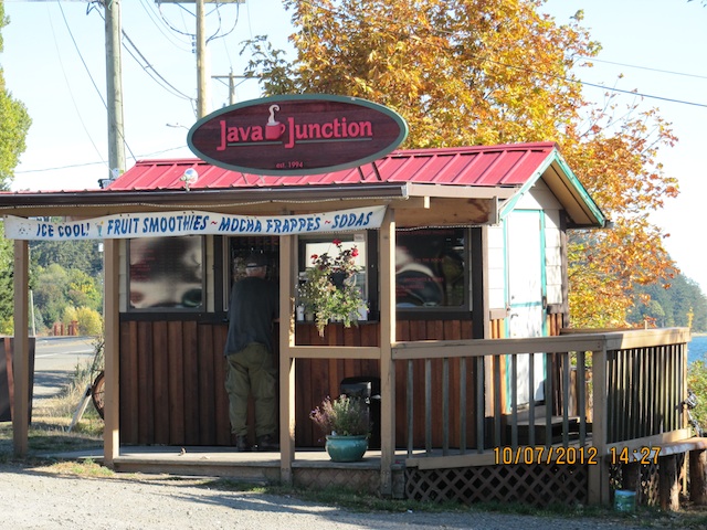 |
Java Junction on Comox Road
|
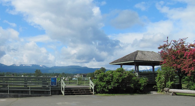 |
Viewing Stand along Comox Road looking over the Estuary
|
 |
View of Estuary taken from viewing stand
|
 |
Picture taken from behind Ships Ahoy food stand
|
_____________________________________________________________________
Indian Reserve #2
Puntledge RV Campground
 |
Sign at entrance to the Puntledge RV Campground
4624 Condensory Rd., Courtenay, BC
Phone:250-334-3773
|
 |
Camp ground office and Nim Nim Interpretive Centre
This campground is located on Puntledge Indian Reserve #2 which is located at the confluence of the Puntledge and Tsolum Rivers adjacent to the City of Countenay. There is a Nim Nim Interpretive Centre at this location. The Puntledge Indian Reserve #2 was allocated in 1867. Learn more about the K'ómoks First Nation, check out the following websites or google for more information.
|
www.ihosgallery.com/history.html
 |
| Trumpeter Swans Most of the Trumpeter Swans arrive in the Comox Valley in January and February. These were photographed in a field along Condensery Road very near the Nim Nim Interpretive Centre. |
_____________________________
Indian Reserve #3
Goose Spit
 |
View of part of Goose Spit
|
Goose Spit, the smallest reserve, is located on a narrow marine sand spit at the Comox Harbour entrance. The reserve formerly known as Graveyard Indian Reserve #3 was also allocated in 1867. Access to the reserve is greatly limited by an existing military base.
__________________________________________________________
The Comox Glacier
 |
Painting of Comox Glacier by R. Ross
___________________
The Comox Glacier
The Comox Glacier is a glacier on Vancouver Island, British Columbia, Canada, located 30 km (19 mi) southwest of Courtenay and 1 km (0.62 mi) west of Argus Mountain.
The highest elevation of the Comox Glacier, 1,960 m (6,430 ft), refers to a rocky outcrop on the north side of the glacier. Lacking an official name, it is referred to as the Comox Glacier summit. The Comox Glacier is a member of the Vancouver Island Ranges which in turn form part of the Insular Mountains.
The name Comox Glacier comes from the name of the K'ómoks First Nation who inhabit the area. They refer to the mountain by the name Kwénis, which means "whale". This name comes from a traditional account of the Great Flood: a whale was said to be trapped up on the mountain when the flood receded. In the early 1900's the glacier was known as Dome Glacier. The name Comox Glacier was officially adopted in 1939, at the suggestion of the Comox & District Mountaineering Club.
http://wikipedia.ogh/wiki/Comox_Glacier
_________________
|
Legend of Queneesh
"Long ago there were big cedar planked houses, totem poles and canoes in the Comox Valley. The nights were very quiet, except for the sounds of the water, sea birds and of hooting owls.
One night an old man, Quio Qwa Lak, had a dream. In that dream a voice told him that he must tell the chief and the Comox people to prepare for a great flood. They built canoes and packed them full of food and clothes.
The young man made a strong cedar rope and took it to the top of the glacier and fastened it tightly. The people tied their canoes to the rope, not to long after it began to rain, it rained and rained for days.
Soon there was only a little of the glacier showing. the Comox People were afraid.
Then all of a sudden the glacier began to move. The people began to cry "White Whale, White Whale! Queneesh, Queneesh/ " The glacier had taken the form of a whale and saved the people. the rain stopped, and Queneesh still stands guard over the Comox people to this very day."
http://www.ihosgallery.com/queneesh.html
_________________________________________________________
Plaque commemorating the arrival
of the first white settler's to the
Comox Valley
 |
Dedication of Cairn
|
 |
Cairn on Headquarters Road near the Old Highland Highway
 |
Names of the first settler's
|
_____________________________________________________________
The next post is
or
Click the posts under Categories for more views of our valley
<<<<<<<<<<<<<<<<<<
_______________________________________________________
This page is copyrighted, please contact the author at rhodaross@telus.net for permission to use.
contact information - my new e-mail is rhodapross@shaw.ca
ReplyDelete